
Autonomous Field Mapper
An AI-driven tool designed to autonomously generate detailed maps of agricultural fields, enhancing precision farming and resource management.

Autonomous Field Mapper
An AI-driven tool designed to autonomously generate detailed maps of agricultural fields, enhancing precision farming and resource management.
Autonomous Field Mapper
SKU: autonomous-field-mapper
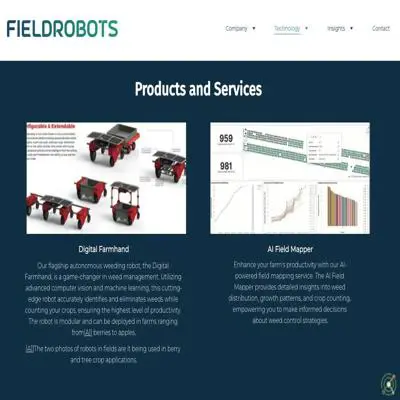
The Autonomous Field Mapper utilizes advanced AI algorithms and autonomous robotics to create precise and up-to-date maps of agricultural fields. By employing technologies such as computer vision and machine learning, it identifies and catalogs various field features, including crop types, weed locations, and soil conditions. This detailed mapping facilitates precision agriculture practices, enabling farmers to optimize resource allocation, monitor crop health, and implement targeted interventions, thereby improving yield and sustainability.
Generating accurate maps of agricultural fields without human intervention.
Identifying and cataloging field features like crop types and weed locations.
Enhancing precision agriculture through detailed field data.
Optimizing resource allocation and monitoring crop health.
The Autonomous Field Mapper demonstrates high autonomy through AI-driven decision-making and real-time environmental analysis without continuous human oversight. It integrates computer vision and machine learning for dynamic navigation and mapping in semi-structured agricultural environments (unlike fully unstructured terrains). While it operates independently for core tasks like soil analysis and crop monitoring, its autonomy is constrained by predefined operational boundaries (agricultural fields) and potential dependency on periodic human validation of AI-generated maps. Compared to Level 4B industrial systems requiring zero human interaction in completely unknown environments , this agent lacks full open-world exploration capabilities but exceeds basic waypoint navigation seen in Level 3 systems .
Closed Source
Paid